Kendyn Webster, director of operations at Vigilant Aerospace Systems, spoke at the inaugural Aviation Leaders in Oklahoma Flight & Technology (ALOFT) Seminar, hosted by Crowe Dunlevy, in Oklahoma City last week.
The event brought together aviation, aerospace, uncrewed aircraft systems (UAS), policy, and economic development leaders to discuss Oklahoma’s aviation future. Webster’s presentation focused on scalable autonomous operations in mixed-use, low-altitude airspace and the infrastructure needed to support beyond visual line of sight (BVLOS) flight.
BVLOS Scalability Depends on Airspace Infrastructure
In the presentation, BVLOS scalability was framed as an airspace integration challenge, not simply an aircraft performance issue.
Beyond visual line of sight (BVLOS) refers to uncrewed aircraft operations conducted beyond the pilot’s direct unaided visual range, requiring additional systems or procedures to maintain safe airspace awareness and separation.
His core point was that safe autonomy depends on infrastructure that can scale to observe, measure, record, and support operations in shared airspace.
A major theme of the presentation was the shift from human visibility to electronic airspace awareness. Webster described “electronic observation” as a practical pathway for BVLOS operations because it can support awareness beyond the physical limits of a pilot or visual observer.
That includes cooperative aircraft, non-cooperative aircraft, drones, terrain, airspace boundaries, and changing field conditions. He also discussed the role of systems such as FlightHorizon TEMPO in creating a common operating picture using radar, ADS-B In, telemetry, drone alerting, and recorded airspace data.
Webster emphasized that safety evidence will be central to authorizing commercial BVLOS operations.
Regulators and operators need records showing what was in the airspace, what was detected, how early it was detected, where coverage was available, and how the system performed across repeated flights.
He connected this requirement to Oklahoma’s investment in aviation infrastructure, including fielded sensing systems and modeled radar coverage at Infinity One Oklahoma Spaceport. These capabilities help move BVLOS programs from isolated demonstrations toward repeatable operations supported by documented safety artifacts.
Watch the full presentation and read the transcript below.
Full Video
Full Transcript
Speaker: Kendyn Webster
Thank you for having me today. I’m really excited to be here in front of this initiative of aviation leaders to talk about something that’s important to me, but also to highlight what state-level investment in infrastructure is doing to further aviation growth.
In fact, this picture up here is a state-owned asset deployed at Burns Flat, which I’m going to highlight a little bit later.
Today, specifically, I want to talk about scalable autonomous operations in mixed-use, low-altitude airspace. That is a mouthful, and it’s not even 10 a.m. But the engineer in me wants to bring forward this conversation: scalable infrastructure is a pathway to commercially viable beyond visual line of sight operations.
For a long time, the attention in autonomous aviation has been on the aircraft, the drones, the battery, the automation, and the payload. That makes sense. The aircraft has matured.
But increasingly, the question is not, can the aircraft fly? That much is obvious. The question now is a little more precise: can the systems operate safely, repeatedly, and at scale inside the national airspace system?
That is a different challenge. It requires us to think not only about aircraft capability, but also about the infrastructure layer that allows aircraft to operate safely in shared airspace.
If I can anchor one thing from my whole talk here, it is that safe autonomy requires scalable infrastructure.
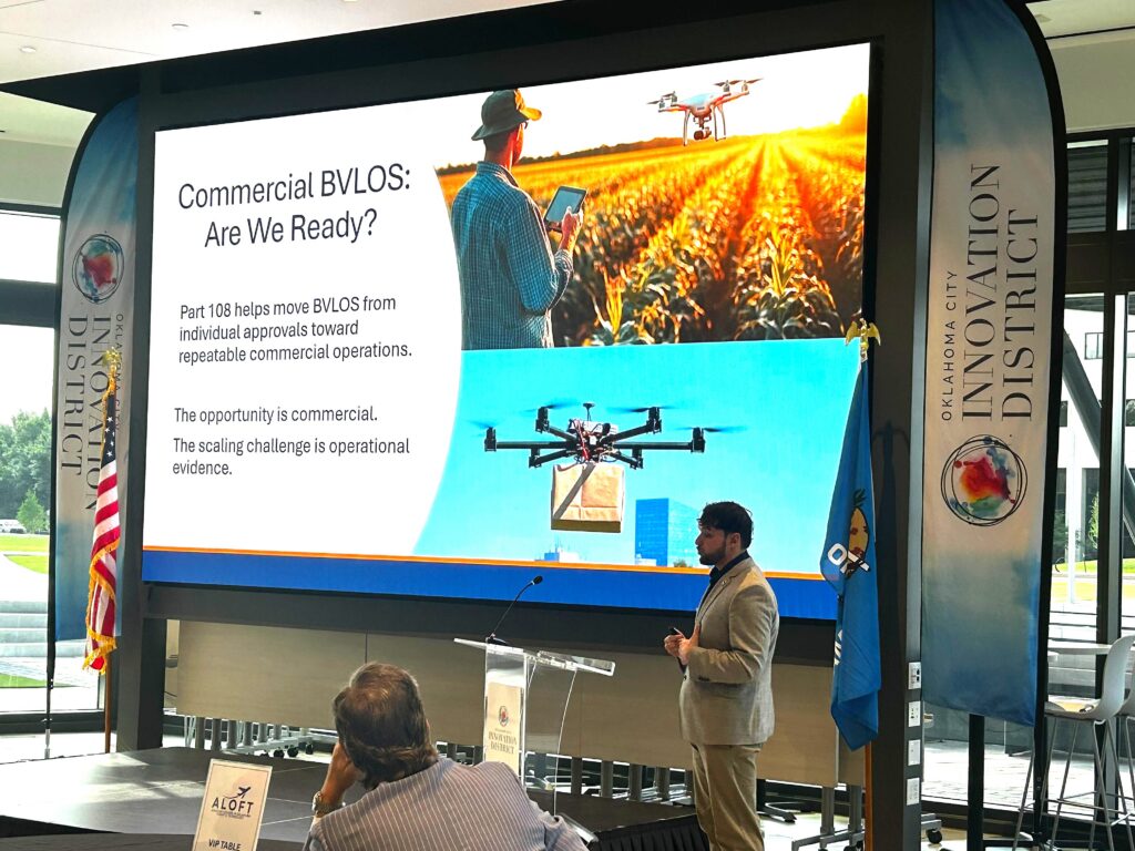
For commercial BVLOS, this is why the timing matters for the state’s investment in these types of systems, especially at Infinity One. Part of this work helps move beyond visual line of sight operations from individual approvals toward more repeatable commercial operations.
This is important because the opportunity is clearly commercial. We can all imagine the applications: package delivery, agricultural operations, infrastructure inspection, emergency response, medical logistics. The list goes on.
Basically, this applies anywhere the aircraft is more valuable when it is not restrained by visual observers. The scaling challenge is operational evidence.
In other words, the regulatory process opens the door. But to walk through that door at commercial scale, operators will have to show that their operations are conducted safely and repeatedly.
That means showing what was in the airspace, what was detected, how the system performed, and whether the risk was managed appropriately.
So the opportunity is commercial, but the pathway has to run through safety evidence.
This is the core shift. Autonomous aviation does not scale by eliminating risk. That may sound odd, but no aviation system eliminates risk entirely.
Aviation scales by identifying, measuring, and mitigating risk, then showing that the residual risk is acceptable for the operation being conducted and for what we care about in shared, mixed-use airspace.
This is especially true for beyond visual line of sight. The new challenge is managing operational risk at scale.
Risk mitigation requires safety evidence. Proving the safety case requires infrastructure. Infrastructure enables data collection at scale.
A single successful demonstration is very valuable to show that a new aircraft works. But it is not the same as proving repeatable, safe operations in shared airspace.
Commercial beyond visual line of sight requires stringent evidence across repeated flights, real environments, changing conditions, and shared airspace. That is where the infrastructure becomes central.
Historically, aviation has depended heavily on human observation: pilots seeing and avoiding, drone operators maintaining visual line of sight, and visual observers extending that awareness.
That model works for limited operations, but increasingly it is not going to work any longer. The human eye does not scale to dense, mixed-use, low-altitude operations across large areas.
At scale, autonomy is fundamentally an observability problem.
Operators need awareness beyond what one pilot or one observer can physically see. They need awareness of cooperative aircraft, non-cooperative aircraft, drones, terrain, boundaries, and changing conditions.
So the question now becomes: how do we move from human visibility to persistent airspace awareness?
This is where electronic observation comes in.
Seeing is limited. It depends on where a person is standing, what direction they are looking, what the weather is doing, and how far away the aircraft is from the observer.
Observation in this context means something broader. It means infrastructure enables the ability to detect, track, display, and record what is actually happening in the airspace in real time.
Electronic observation is a scalable pathway because it does not rely on simply adding more people to the operation.
It allows us to move from a standalone observer model toward networked sensors, integrated data, and eventually broader shared awareness across larger systems.
We are not saying that the human role will disappear entirely. The point is that the human role has to be supported by infrastructure that observes the airspace consistently and more broadly than the human eye alone.
Currently on this roadmap, we are pretty much over here on the left, where we are employing electronic observation to increase situational awareness.
But the future could look like this: Unmanned Traffic Management, autonomous systems at scale, and shared infrastructure. That is the pathway we set ourselves on with some of the investment the state is making to further grow the aviation industry.
This brings me to what matters most. This is where the Oklahoma story matters.
Oklahoma is investing in an infrastructure layer needed to support scalable autonomous operations. The goal is not just to install sensors. It is to generate operational evidence for the safety case.
That distinction matters. The sensor by itself is just a piece of equipment. Infrastructure is what happens when those sensors are placed, networked, modeled, integrated, and used to support real operations.
At Infinity One Oklahoma Spaceport in Burns Flat, Oklahoma, the work is about building an environment where low-altitude airspace can be observed, measured, understood, and specifically quantified for safety.
That is important for operators, regulators, and communities. It is also important for Oklahoma’s ability to support the next stage of aviation growth.
This map shows some theoretical placements where we would plan to put S-200 radars and their approximate detection range.
I will get into this a little later, but the detection range from the manufacturer is not always what the sensor can actually see. That is part of the work related to deploying these sensors in the field.
There are layers to all this. Infrastructure enables electronic observation.
On one side here, you have a fielded radar. This is a 3D, 360-degree radar. It is a significant advancement in radar technology. Unlike traditional radar systems, where we see something on the plane and say, “It is over there,” this can say, “It is over there, and it is also this high up in the air.”
That gives rapid situational awareness in relation to where your aircraft is versus where another aircraft is in time and space.
On the other side here is the common operating picture. This is what my company specializes in. This is FlightHorizon TEMPO, our company’s flagship system deployed at Infinity One.
It integrates radar data, ADS-B in, telemetry, drone alerting, airspace boundaries, and, most importantly for regulators, it records what happens in the airspace.
The value of these systems is not just what they see. The value is that they turn multiple sources of data into a usable operating picture to support safe operations and the decision layer, meaning what the pilot is doing in real time.
It is also important because, as I said, it creates a safety record.
When we talk about scaling beyond visual line of sight, we are not only talking about real-time awareness. We are also talking about what can be shown after the operation. These are the safety artifacts.
What happened? What was detected? How early was it detected? How did the system perform?
That record is part of the safety case and is probably one of the most important artifacts.
This slide brings the concept to real-world deployment. FlightHorizon TEMPO integrates radar, ADS-B in, drone telemetry, and alerting, and it creates a common operating picture.
It is deployed at Infinity One Oklahoma Spaceport in Burns Flat, Oklahoma, where the primary goal is to replace visual observers with electronic observation and to prove the safety case to the FAA that integrating drones into the national airspace is viable, specifically when enabled by infrastructure.
This matters because commercial viability depends on repeatability.
If a company wants to operate beyond visual line of sight at scale, it needs more than confidence that the aircraft can complete the flight safely.
It needs evidence that the system can detect all relevant traffic, including non-cooperative traffic that is not broadcasting its location, or drones that are not compliant with Remote ID rules.
It needs evidence that operators can maintain awareness and that the operation can be repeated under real-world conditions.
This is the bridge from demonstration to commercial operation. It is why operational evidence supports commercial viability.
Oklahoma is already ahead of the curve by deploying these systems to start proving what the safety case for integrating drones into the airspace could look like.
But there is ongoing work. It is not enough to buy a radar. You have to engineer observability.
This is a very technical diagram. The nerd in me wants to get into it, but I will keep it at a high level.
Basically, observability has to be engineered. Radar placement matters. The sensor itself matters. Terrain matters. Modeling the airspace accurately to what the sensor can see matters.
This picture on the slide is a good example. You can get a pretty good approximation of what the radar would see. But in real-world deployments, if there is a hill on the bottom right here, you may not see your drone when it goes over that hill.
That is some of the work required when deploying sensors: clutter mapping them and understanding what they actually see.
It is important when the goal is to support flights beyond visual line of sight. If we want to rely on electronic observation, we need to understand the performance of that observation.
This brings me to the next step and the ultimate goal of this deployment. We need to turn all of this awareness and all of this observation into repeatable safety artifacts that can show the FAA that we are doing something safe, that we are mitigating risk, and that we are collecting data not for data’s sake, but to use as safety evidence.
This includes flight activity, sensor performance, coverage results, detection history, and operational records.
Over time, that information will help answer the questions that matter for the safety case.
What was in the airspace? What was detected? Where was the coverage? Where were the limitations? How did the system perform across repeated operations?
It helps produce the evidence needed to improve operations as a whole, support approvals, inform procedures, and build confidence in commercial BVLOS.
This right here is called a viewshed. What you are looking at is a theoretical view of what the radar can and cannot see.
The green areas show where the radar can see. The areas not colored in green show where terrain may block the radar’s view.
When we deploy these systems, we need to take into account the geometry of the radar and what is actually happening up there.
This leads me to the full system view.
Aircraft capability is very necessary. Having a drone that can perform a beyond visual line of sight mission because of its batteries, rotors, and other aircraft systems is great.
But aircraft capability alone does not create scalable autonomy.
The next layer is airspace observability. That is where Oklahoma is putting these systems in place to start proving the case.
From observability, we get operational evidence. From operational evidence, we can support scalable autonomy.
That is really the main point of my talk: infrastructure is what connects aircraft capability to scalable autonomy.
Without the infrastructure layer, we may have capable aircraft, but we do not yet have a full system that can support the safety case for operations in shared airspace.
Autonomous aviation is not just an aircraft problem. It is an airspace integration problem enabled by an infrastructure layer.
That is what Oklahoma is doing today, and that is what my company is working on.
Thank you.
About Crowe Dunlevy
Crowe Dunlevy is a law firm with offices in Oklahoma City, Tulsa, Dallas, and Houston. The firm provides legal services across nearly 30 practice areas and serves clients ranging from individuals to Fortune 500 companies. Crowe Dunlevy has served Oklahoma clients for more than 120 years, with roots dating back to its founding in Oklahoma Territory in 1902.
About ALOFT
Aviation Leaders in Oklahoma Flight & Technology is a Crowe Dunlevy initiative designed as an industry-focused forum for Oklahoma aviation, aerospace, aeronautics, and UAS professionals. ALOFT brings together executives, innovators, academic partners, policymakers, and economic development leaders to discuss workforce, technology innovation, advanced air mobility, and emerging UAS applications.