Long-Range Inspection of Vast Pipeline Infrastructure
Climate and Land Restrictions Create Great Demand for Beyond Visual Line-of-Sight Operations
All of the test cases proposed by the team are major concerns in Alaska as the local climate often produces impassable roads, avalanches, and extremely harsh weather, making already rough terrain nearly impossible to navigate for much of the year.Bad Road Conditions and Avalanches Create Impassable Routes
Cahill told Inside Unmanned Systems that drones could be a valuable tool for surveying roadways to discern the status of routes. “For example, up in Thompson Pass, which is down by Valdez, (the Department of Transportation) is concerned about avalanches. They’re concerned about deteriorating roadways, asphalt, etc., [,,,] They’ve got an airport that they need to survey for obstructions.” “This is going to be something in Alaska that’ll be very important,” Cahill said in the article. According to the article, when routes are inaccessible, drones can provide an expedient means to deliver important goods – like medical supplies – to remote areas that are inaccessible by road. Cahill told Inside Unmanned Systems, “We have very few roads and often the roads are in terrible condition in the middle of winter.”Wildlife Surveying and Other Wilderness Flights Are a Compelling Need

Aircraft flying over Denali National Park, Alaska Photo Credit: National Park Service
Long Winter Nights Provide Excellent Test Case for Night Operations
Although operations beyond visual line-of-sight are a primary focus for the team, proving safety cases for night operations have a particular importance in Alaska due to the long nights in the northern regions. According to Alaska.org, during the winter, Alaska experiences the shortest daylight periods of any U.S. state. At the peak of winter Fairbanks, Alaska, the location for the ACUASI facilities, experiences only 3 hours 42 minutes of daylight and Barrow, Alaska, the northernmost town in Alaska located 330 miles north of the Arctic Circle, experiences 67 days of darkness (November 18 – January 23). With few daylight hours in which to work, proving night operation safety cases is necessary in order to fully integrate drone operations into the Alaska airspace year-round.FlightHorizon in the Alaska IPP
Proving a safety case for unmanned flight operations beyond visual line-of-sight and is a major focus and obstacle to true integration of drones into the national airspace. This is where Vigilant Aerospace’s FlightHorizon detect-and-avoid and airspace management product becomes key. FlightHorizon provides airspace managers and pilots with a 2D or 3D view of all aircraft in the selected airspace using a combination of sensors and data sources to create an airspace safety picture. The system is a solution which enables pilots to detect, track, predict, and avoid other aircraft. The software sends commands to self-separate and maintain well-clear distances to the unmanned aircraft pilot, or autopilot, to avoid conflicts quickly and efficiently. Once the potential mid-air collision is avoided, the system redirects the pilot onto the original flight path.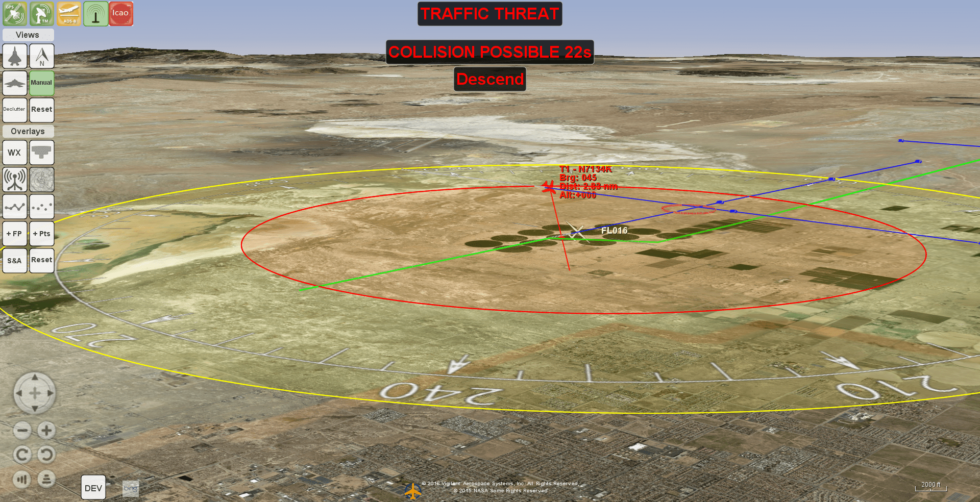 The system uses algorithms and flight rules to deliver a complete solution for safety and regulatory compliance for beyond visual line-of-sight flying and is based on an exclusively licensed NASA patent and prototype. The system accepts data from aviation transponders and, when available and integrated, air traffic control systems, networked traffic management systems and radar feeds.
The system is comprised of a software program that runs on a tablet or laptop computer that is (a) used by the unmanned aircraft pilot during flight; or (b) that runs on an independent flight computer on the aircraft connected to the autopilot; or (c) as an independent software module on the primary flight computer.
The software accepts signals from aviation receivers on the ground or onboard the aircraft and, when available, from other data sources, like ground-based radars, onboard radar, and networked traffic feeds (like the FAA’s air traffic control feed or NASA’s Unmanned Traffic Management system – UTM).
FlightHorizon COMMANDER is a situational awareness and safety system for airspace management. FlightHorizon COMMANDER functions as both a visualization tool for airspace management, and active situational awareness tool and as a detect-and-avoid (aka sense-and-avoid) system that enables unmanned aircraft (drones) to avoid other aircraft and keeps drone pilots and air managers aware of the location and air traffic around their drone and in their airspace. The system provides the ability to designate one or more aircraft as “ownship” and to track those aircraft specifically for airspace management and provides commands to maintain well-clear distances with visual cues and text and audible advisories.
Aircraft target states are recorded up to five times per second and recorded into a flight log. Flights recorded with FlightHorizon provide detailed flight logs allowing for each mission to be re-played and reviewed at a later date.
For more information on FlightHorizon, visit our Products and Services Overview. Or, contact us today to get started with FlightHorizon.
Articles and Web Resources:
The system uses algorithms and flight rules to deliver a complete solution for safety and regulatory compliance for beyond visual line-of-sight flying and is based on an exclusively licensed NASA patent and prototype. The system accepts data from aviation transponders and, when available and integrated, air traffic control systems, networked traffic management systems and radar feeds.
The system is comprised of a software program that runs on a tablet or laptop computer that is (a) used by the unmanned aircraft pilot during flight; or (b) that runs on an independent flight computer on the aircraft connected to the autopilot; or (c) as an independent software module on the primary flight computer.
The software accepts signals from aviation receivers on the ground or onboard the aircraft and, when available, from other data sources, like ground-based radars, onboard radar, and networked traffic feeds (like the FAA’s air traffic control feed or NASA’s Unmanned Traffic Management system – UTM).
FlightHorizon COMMANDER is a situational awareness and safety system for airspace management. FlightHorizon COMMANDER functions as both a visualization tool for airspace management, and active situational awareness tool and as a detect-and-avoid (aka sense-and-avoid) system that enables unmanned aircraft (drones) to avoid other aircraft and keeps drone pilots and air managers aware of the location and air traffic around their drone and in their airspace. The system provides the ability to designate one or more aircraft as “ownship” and to track those aircraft specifically for airspace management and provides commands to maintain well-clear distances with visual cues and text and audible advisories.
Aircraft target states are recorded up to five times per second and recorded into a flight log. Flights recorded with FlightHorizon provide detailed flight logs allowing for each mission to be re-played and reviewed at a later date.
For more information on FlightHorizon, visit our Products and Services Overview. Or, contact us today to get started with FlightHorizon.
Articles and Web Resources:
- University of Alaska-Fairbanks News: “UAF selected for new federal drone program”
- Alaska Center for UAS Integration (ACUASI) website: ACUASI.Alaska.edu
- InsideUnmannedSystems.com: “Reaching for the Horizon – IPP Alaska”
- Alaska.org: “Shortest Day in Alaska”