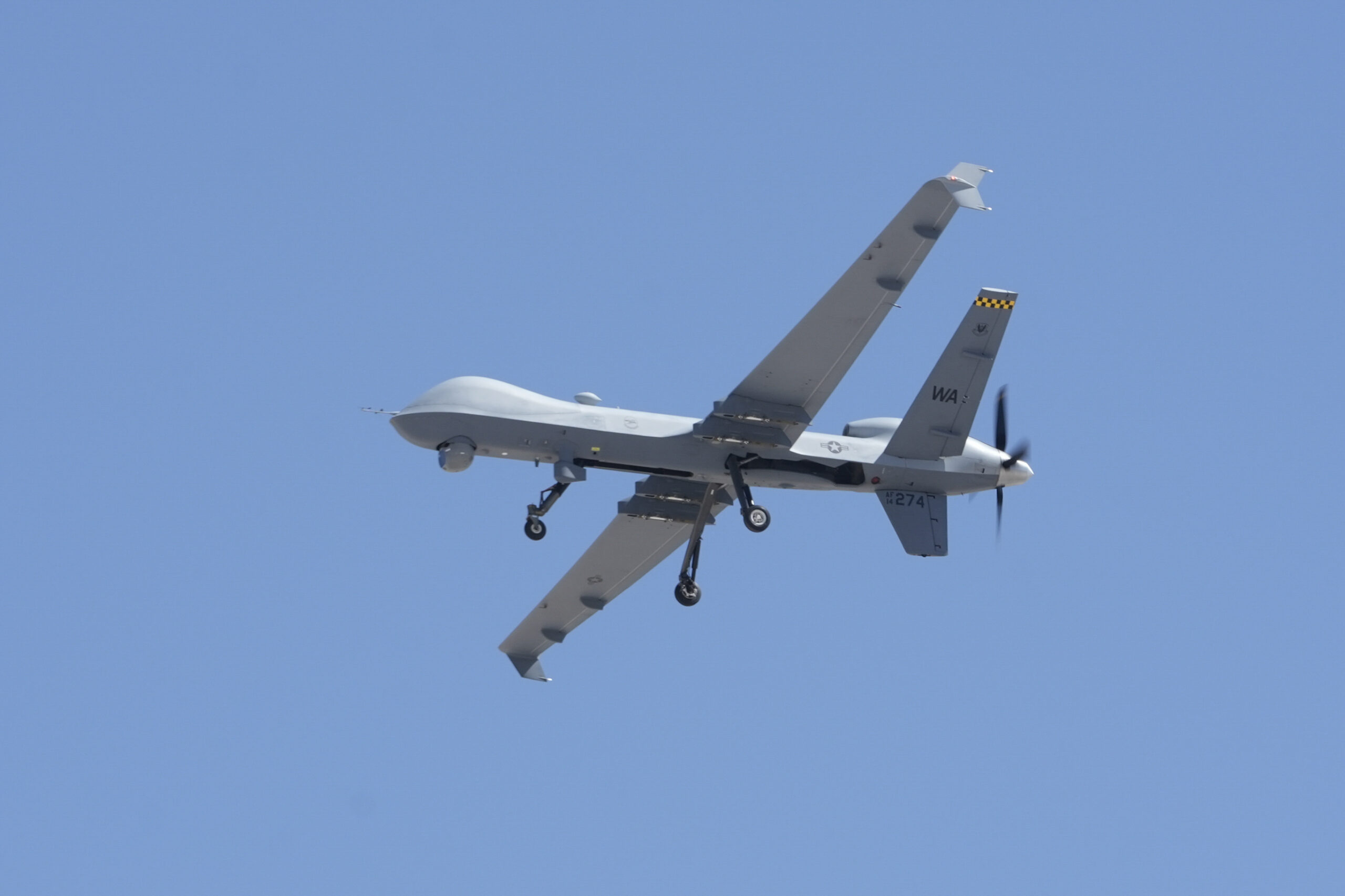
Vigilant Aerospace Systems demonstrated FlightHorizon TEMPO, its airspace management system, integrating with surveillance radar and other sensors in support of military drone flights during a recent demonstration at UND Aerospace’s Gorman Field. The July 16 demonstration combined live U.S. Air Force and North Dakota National Guard aircraft, including the MQ-9 Reaper and RQ-4 Global Hawk, with simulated threat aircraft in a Live Virtual Constructive (LVC) training environment.
Gorman Field, located in Grand Forks, ND, is one of the nation’s premier UAS testing and development facilities and has been host to numerous military and civilian advanced drone flights and demonstrations.
The demonstration was coordinated by the University of North Dakota (UND) John D. Odegard School of Aerospace and the North Dakota Army and Air National Guard. Vigilant Aerospace showed FlightHorizon TEMPO managing shared airspace using radar and transponder inputs to display a real-time map of aircraft flying overhead. Military and academic uncrewed aircraft operated simultaneously with real-time, multi-user coordination.
The exercise illustrated how integrated surveillance and software-based airspace management can support complex operations involving crewed and uncrewed aircraft, including long-range and military platforms, while maintaining a common operating picture across distributed users.
Live Airspace Operations at Gorman Field
During the demonstration, FlightHorizon TEMPO monitored and displayed multiple aircraft types operating concurrently, including:
Small uncrewed aircraft systems (UAS) operated by UND, simulating adversarial incursions
A Boeing Insitu ScanEagle conducting operations “beyond visual line of sight” (BVLOS)
The scenario replicated a dense, mixed-use airspace environment, requiring coordination between military units and academic operators. Participating aircraft were displayed on a shared, real-time airspace display, supporting aircraft deconfliction and coordinated decision-making.
FlightHorizon TEMPO fused data from multiple surveillance sources, including radar, Automatic Dependent Surveillance–Broadcast (ADS-B), Remote ID, and additional onboard and ground-based sensors. This integration enabled continuous monitoring of cooperative and non-cooperative aircraft within the test range airspace.
The system supported ‘detect-and-avoid’ (DAA) methodologies by providing live traffic visualization, predictive trajectory overlays, and alerting to assist in maintaining safe separation. Hosted on a secure remote server, FlightHorizon TEMPO allowed multiple authorized users to access the same airspace picture simultaneously, supporting distributed operations.
3D view from Vigilant Aerospace’s FlightHorizon™ system shows four nearby aircraft tracked using radar and ADS-B signals. This advanced software helps drone operators detect and avoid other aircraft by combining data from multiple sensors and displaying it on a live map — a critical capability for flying safely beyond visual range.
Public-Private Collaboration
Military and UND Leaders at Gorman Field (Photo by Joe Banish, UND Today)
Military leaders taking part in the demonstration emphasized the importance of collaborative environments that integrate academic, government, and operational partners.
Col. Ryan Ayers, deputy commander of the 119th Wing of the North Dakota Air National Guard, described the effort at Gorman Field as,
“The type of collaboration, integration, and initiative Defense Secretary [Pete] Hegseth has directed us to get after. We are all-in on unleashing U.S. military drone dominance.”
Col. Alfred Rosales, commander of the Air Force 319th Reconnaissance Wing, highlighted the role of uncrewed systems in current readiness planning.
“Harnessing the potential of unmanned systems is no longer a future aspiration, but a present-day necessity. This partnership with UND and our fellow North Dakota National Guard units is crucial to staying ahead of emerging threats and ensuring our continued readiness.”
Vigilant Aerospace CEO Kraettli Epperson emphasized that these live, integrated demonstrations provide practical validation of airspace management concepts.
“This type of demonstration highlights the operational value of an integrated, real-time airspace management system and the effectiveness of a distributed, multi-user DAA and visualization environment.”
Supporting UAS Workforce Development and Training
Beyond operational demonstrations, Vigilant Aerospace supports UAS workforce development through an academic partnership with UND’s John D. Odegard School of Aerospace Sciences. FlightHorizon TEMPO is set to be integrated into coursework and field training at Gorman Field, allowing students to work with operational airspace management software in both classroom and live-flight environments.
Students will use the system as part of a FlightHorizon certification process that combines software operation with applied airspace management concepts.
Paul Snyder, Director of UND Aerospace’s UAS Operations Program, emphasized the value of exposing students to operationally relevant systems:
“Watching these students and recent graduates collaborate with accomplished professionals is truly inspiring. They’re not just learning—they’re envisioning what’s possible.”
The partnership focuses on advancing education and training related to BVLOS flight, UAS traffic management (UTM), counter-UAS (C-UAS), and integrated airspace operations. Vigilant Aerospace’s platform agnostic software framework is a large part of why the school sought out the collaboration, Paul Snyder goes on to say,
“The software that Vigilant Aerospace provides easily integrates with our existing hardware to create a common operating picture that enables us to fuse hardware and data from DeTect radars and onboard drone sensors into one screen.”
Advancing safety with Scalable Airspace Management
The demonstration at Gorman Field reflects a broader focus on deploying scalable, platform-agnostic airspace management capabilities that support both ground-based and onboard sensing and DAA. FlightHorizon’s architecture is designed to integrate with diverse sensor and aircraft ecosystems, enabling use by military units, civilian drone operators, test ranges, and airports.
Future collaboration between Vigilant Aerospace and the John D. Odegard School of Aerospace Sciences includes expanding the radar network at Gorman Field, continued testing, education, and military cooperation.
About the University of North Dakota John D. Odegard School of Aerospace Sciences
The University of North Dakota’s John D. Odegard School of Aerospace Sciences is a national leader in aviation and uncrewed aircraft education. The program supports advanced UAS research, flight operations, and workforce development, with active partnerships across government, military, and industry organizations.
About the 119th Wing, North Dakota Air National Guard
The 119th Wing is a unit of the North Dakota Air National Guard operates the MQ-9 Reaper and supports intelligence, surveillance, and reconnaissance missions for state and federal authorities. It also conducts domestic operations, training, and homeland defense missions in support of both the Governor of North Dakota and the U.S. Air Force.
About the 319th Reconnaissance Wing, U.S. Air Force
The 319th Reconnaissance Wing is an active-duty unit of the U.S. Air Force stationed at Grand Forks Air Force Base in North Dakota. The wing operates the RQ-4 Global Hawk and provides high-altitude, long-endurance intelligence, surveillance, and reconnaissance capabilities in support of global combatant commanders. Its mission focuses on delivering persistent, worldwide reconnaissance through remotely piloted aircraft operations.
About Vigilant Aerospace Systems
Vigilant Aerospace is the leading developer of multi-sensor detect-and-avoid and airspace management software for uncrewed aircraft systems (UAS or drones). The company’s product, FlightHorizon, is based on two NASA patents and uses data from multiple sources to display a real-time picture of the air traffic around a UAS and to provide automatic avoidance maneuvers to prevent collisions. The software is designed to meet industry technical standards, to provide automatic safety and to allow UAS to safely fly beyond the sight of the pilot. The software has won multiple industry awards and the company has had contracts and users at NASA, the FAA, the U.S. Department of Defense and with a variety of drone development programs. Visit our website at www.VigilantAerospace.com


